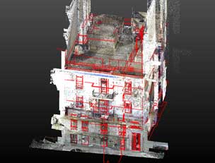
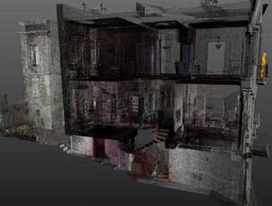
The process of scanning the construction yields a numerous cloud of points which describe the building to the nearest millimeter. For example, the individual elements of a building are captured in this way in detail and can be preserved as important historical elements. This cloud (point cloud) is then used to create the exact three-dimensional model and two-dimensional representations that are the first step in its design and restoration.
A detailed illustration of the existing shell also contributes to a more accurate budget of the cost of the work, reducing the cost of additional work that arises unexpectedly in the course of a renovation. Obtaining all the information about the “as-built” condition of the building is then integrated into the BIM, which will follow the construction throughout its life. The BIM contains information on both the current condition and the intervention in the construction and is used by the architects and engineers before the renovation, but also by the owner with those responsible for the smooth operation and maintenance of the building for this purpose.
The process and the products are:
- 3D Laser Scanning of all areas of the listed building
- Creating a 3D Model
- Create BIM
- Production of floor plans of all levels, sections and facades, production of elevation topographic plan for the issuance of the construction permit of the restoration