For engineers who need every detail of the 3D project space we offer a high precision and high resolution Point Cloud. This Cloud is cleared of unnecessary elements and is georeferenced to the appropriate reference grid.
The widespread and major software vendors now offer their design packages with capabilities to import and manage this rich information.
Our Clients who design directly in the 3D Point Cloud space enjoy the rich information they receive from us as well as the Virtual Project Space Tour with very powerful Precision Measurement tools in the High Resolution 360 degree Photos.
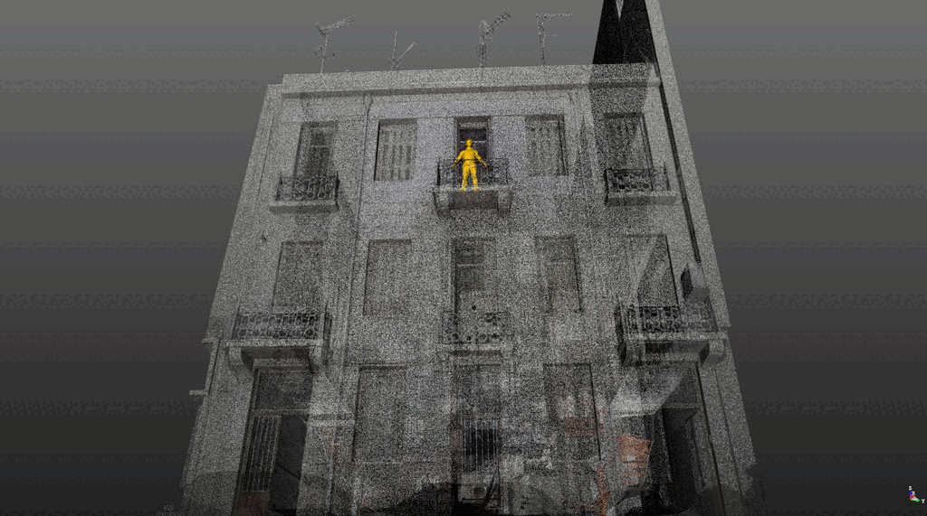
The Point Cloud or Point Cloud is the end result of the 3D Scanning we do on the sites of your interest. Each point in the Point Cloud has x y z coordinates in space. At the same time, each point contains the color information and is associated with the elementary trace elements (pixels) captured by a camera located inside the same instrument. Thus, millions of points – pixels in three dimensions are captured in space.
The accuracy of the measurements and the relative positions of the points is in the order of a thousandth of a metre.
The high density of points combined with the possibility of colour information in each point approximates the term “virtual reality”.
The Color Point Clouds with Georeferencing – Dependence in the E.G.S.A.’87.
FOR CLIENTS WISHING TO COMPLETE THEIR OWN PRODUCTION MOUNTS WE CAN SCAN AND SUPPLY A REGISTERED CLOD POINT
3D laser scanning or high resolution surveys are a fast and efficient way of collecting spatial data of the environment. Recently, major software vendors have incorporated cloud point tools into their products. This has led to scanning increasingly becoming a standard method of data acquisition for a wide range of applications. From architectural to industrial, 3D cloud point survey can provide a solution to the most complex data collection challenges.
Some of our customers prefer to create their own products from cloud point data. In these cases, we can provide a registered point cloud, filtered to your specifications and delivered in a format of your choice.
Where the client would not have enough experience or manpower to convert the cloud to CAD data, we may offer our additional 3D cloud point processing services.
For more experienced cloud point users, we can offer enhanced services.
The main scan data formats supported by 3Deling include:
- .POD – Pointtools and Bentley format
- .PCG and RCS formats – AutoDesk.
- .IMP, PTX, – Leica formats
- .ZFC format – Aveva,LFM Modeller
- .PTS, XYZ – standard ASCII formats
In addition to the point cloud, we recommend TruView – panoramic views of individual scans with a choice of simple measurements and coordinate display. Panoramic images linked to a standard intensity point cloud provide an efficient dataset for modelling.
Practical applications include:
- Construction inspections or construction verification
- Generating a baseline dataset for documentation of heritage sites
- Generate 3D or 2D CAD documentation for urban and architectural design
- 3D CAD for design and construction of 3D architectural drawings for the creation of 3D architectural drawings for the construction of 3D CAD for the creation of 3D architectural drawings
- Right of Lights
- Volume surveys
